.png)


RTK vs. PPK in Drone Mapping: What’s the Difference and Why It Matters
When it comes to drone mapping, achieving high-precision geospatial data is critical. Industries like construction, agriculture, mining, and land surveying rely on centimeter-level accuracy for tasks ranging from site analysis to volumetric calculations. Two of the most widely used technologies that enhance GPS accuracy in drone operations are RTK (Real-Time Kinematic) and PPK (Post-Processed Kinematic). While both are designed to improve geolocation data, they operate differently and suit different mission needs. Understanding the distinctions between them can help drone operators and businesses make informed decisions based on their specific use cases.
What is RTK (Real-Time Kinematic)?
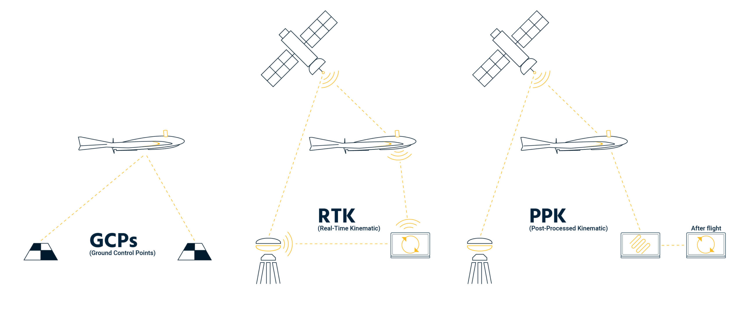
RTK is a satellite navigation technique used to correct the positional data collected by drones in real time. It involves a base station placed at a known location on the ground that sends correction signals to the drone as it flies. This method allows the drone to adjust its GPS data on-the-go, delivering near-instant positional accuracy. RTK systems typically use a radio link or cellular network to transmit these corrections, ensuring that the positional data is refined before it is logged.
One of the biggest advantages of RTK is the speed and convenience it offers. Since corrections are applied in real time, there's little to no need for data processing after the flight. This makes RTK particularly useful for time-sensitive missions, such as construction progress monitoring or real-time inspections. However, this approach is highly dependent on maintaining a constant and stable connection between the drone and the base station. If this connection is lost — for example, due to terrain obstacles or network outages — the accuracy of the data may be compromised.
What is PPK (Post-Processed Kinematic)?
PPK, on the other hand, applies GPS correction data after the drone flight. Like RTK, it uses a base station, but instead of sending corrections live during the flight, both the drone and the base station record their respective GPS data independently. After the mission, this data is matched and corrected in post-processing software to produce highly accurate geospatial information.
The main strength of PPK lies in its reliability. Since it doesn’t require a live connection during the flight, it's more suitable for operations in remote or obstructed areas, such as forests, valleys, or urban environments with limited signal coverage. Although PPK adds an extra step to the workflow, this added layer of processing often results in fewer errors and more consistent accuracy — even in challenging conditions.
RTK vs. PPK: Side-by-Side Comparison
While both RTK and PPK aim to provide the same end result — precise drone positioning — their workflows differ significantly. RTK offers instant correction and faster turnaround, which can be ideal for jobs that require real-time results. However, it depends heavily on uninterrupted communication between the drone and the base station. On the other hand, PPK provides more flexibility and resilience, especially when working in difficult terrain or environments where maintaining a data link is problematic. The trade-off is that it requires additional processing time after the flight.
Which One Should You Use?
Choosing between RTK and PPK depends on several factors including your project’s timeline, the working environment, and your operational preferences. RTK is best suited for projects where you need immediate data output and are operating in areas with stable communication links. This includes use cases like live construction site mapping or infrastructure inspections where time is critical. Meanwhile, PPK is the preferred choice when operating in areas where signal reliability is an issue. It’s particularly advantageous in mountainous regions, densely forested areas, or large agricultural fields with limited connectivity.
Ultimately, both technologies are capable of delivering highly accurate results. The decision comes down to balancing real-time convenience with post-flight reliability and determining which approach aligns best with your mission goals.
Final Thoughts
As drone mapping continues to grow in both commercial and industrial sectors, technologies like RTK and PPK are essential for achieving the precision required in high-stakes applications. Whether you choose RTK for its speed or PPK for its robustness, both options will significantly improve your data quality compared to standard GPS. By understanding their differences and ideal use cases, drone operators can optimize their workflows, avoid costly errors, and ensure success in their mapping missions.
Leave a Comment
Your email address will not be published. Required fields are marked *