.png)


Navigation Aids in Aviation
Navigation aids assist pilots in determining their position, direction, and distance during flight, ensuring safety and efficiency. Ground-based systems like NDB, DME, and VOR provide essential signals for navigation, while ILS enhances landing precision in low-visibility conditions. Advanced satellite-based systems, such as GPS and GNSS, offer real-time global positioning. Air Traffic Controllers (ATC) and radar systems further regulate airspace and prevent collisions. Continuous advancements in navigation technology contribute to safer and more reliable air travel.
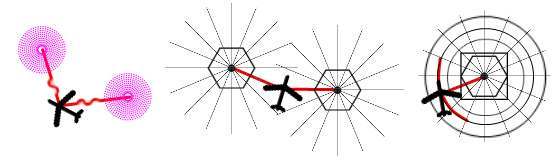
Non-Directional Radio Beacon (NDB) is a ground-based radio transmitter that emits signals at low or medium frequencies to help aircraft determine their heading. Unlike other navigation systems, NDB does not provide directional information but enables pilots to identify their position relative to the beacon. Aircraft equipped with the necessary receivers can utilize these signals for safe navigation, making NDB an essential component of air navigation.
Distance Measuring Equipment (DME) functions by transmitting pulse waves from ground stations. It does not offer directional data but measures the aircraft's distance from the station. This technology improves situational awareness and supports other navigation systems, enhancing flight efficiency and safety.
VHF Omni-Directional Range (VOR) stations transmit signals that create 360 radials at one-degree intervals around the station. Pilots use VOR data to determine their radial position and navigate accordingly. These stations operate in the VHF band, providing precise positioning based on a selected radial. VOR technology is widely employed for airport location identification, with types like NVOR (Normal VOR), TVOR (Terminal VOR), and DVOR (Doppler VOR) catering to different aviation requirements.
Aircraft equipped with these navigational aids can operate safely from takeoff to landing, but additional systems and protocols are necessary for flight safety. Air Traffic Controllers (ATC) regulate aircraft movement, ensuring separation and collision avoidance. Radar and satellite-based systems further enhance situational awareness, enabling safe navigation in various conditions.
When approaching an airport, the landing phase becomes critical. In clear weather, pilots can execute a visual landing. However, when visibility is low due to fog or inadequate lighting, an Instrument Landing System (ILS) is required. ILS is a precision approach system that includes Localizer (LLZ), Glide Path (glide slope), Marker beacons, and approach lights. It guides aircraft along a predefined approach path, ensuring a smooth and accurate descent. The system engages aircraft from approximately 12 miles away, directing them at the correct altitude and angle for a safe landing.
ILS is classified based on accuracy and operational conditions. Category I allows landings with a decision height of 200 feet and a visibility range of 550 meters. Category II enhances precision, permitting landings with a decision height of 100 feet and a visibility range of 300 meters. Category III, the most advanced, is divided into IIIA, IIIB, and IIIC, enabling landings in extremely low visibility, down to zero visibility conditions for Category IIIC. The significance of ILS Category III lies in its ability to facilitate landings in adverse weather, ensuring uninterrupted airport operations and enhancing overall flight safety.
Navigation aids such as NDB, DME, and VOR, combined with advanced systems like ILS, play a vital role in modern aviation. They enhance navigation accuracy, improve safety, and ensure efficient air traffic management. As technology progresses, these systems continue to integrate with satellite-based solutions, further improving the precision and reliability of air navigation.
Leave a Comment
Your email address will not be published. Required fields are marked *